Attractions


97308 Yucatan, Mexico
Dzibilchaltún
Considered one of the oldest Mayan cities, whose name means "the place where there is writing on flat stones." Dzibilchaltún brings together in a single site a pre-Hispanic city, an eco-archaeological park and the Museum of the Mayan People, which houses Mayan and Spanish vestiges, from clay objects to paintings, Spanish armor and weapons, various Mayan stelae, stones and carved lintels. in excellent condition.


Paseo de Montejo, Zona Paseo Montejo, Centro, Mérida, Yucatan, Mexico
Paseo Montejo
Paseo de Montejo, is the name of a main road in the city of Mérida, Mexico, named after Francisco de Montejo, conqueror of Yucatán and founder of the capital city of Yucatán. It is an avenue that runs from the Santa Ana neighborhood, in the center of the city, to the exit towards the port of Progreso, Yucatán, including the extensions made at different times. Numerous public and private institutions are located along its route and it is the main part of the Mérida tourist corridor. The layout and design are inspired by that of the French boulevards, especially that of the Champs Elysees in Paris. Flanked by large trees, it has a median and numerous roundabouts. On both sides of this avenue, beautiful palaces and mansions of wealthy people from the Yucatan of the 19th century were built. Along its line, the Paseo de Montejo contains important monuments and buildings that are emblematic of the City of Mérida and the state of Yucatán. This avenue was built to commemorate the founder of Mérida, Francisco de Montejo y León (el Mozo). Including the so-called Prolongación del Paseo de Montejo, it has an extension greater than 6 km, which makes it one of the longest roads in the city. https://es.wikipedia.org/wiki/Paseo_de_Montejo
Celestún, Yucatan, Mexico
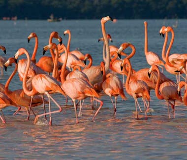
Celestún
Eco-touristic paradise in the state of Yucatan. Its exceptional landscape is part of the world heritage of the special biosphere reserve of the same name; with an area of 59,139 ha., and a length of 21 km., officially declared a wildlife refuge since 1979. Among its natural attractions are, to the east, the Baldiosera spring where you can swim and dive; There is also the Cambay spring which is a spring of fresh water, and finally there is Tambor, where the main attraction is the pink or Caribbean flamingo, the only known population in North America and which has the Celestún estuary as a feeding and resting point. ; Celestún's flamingos are the pinkest in the world, due to the concentration of carotene in the water. They can be observed in their natural ecosystem aboard boats guided by locals.
Best time in the year to go is from October - April


Sisal, Yucatan, Mexico
Sisal
Legendary coastal port with white sand beaches and exotic natural settings. Beautiful migratory birds such as the Canadian duck arrive on time each year seeking the shelter of the warm waters of the Gulf of Mexico.
When Campeche had been the main port of the Peninsula for 270 years, monopolizing all the products that were sent to the region, at the time of Don Benito Pérez Valdelomar by Royal order of February 13, 1810, the opening of Sisal for the unloading of ships from Havana and on March 3, 1811 it was declared a minor port.
One of the first ships that operated in that place was the American schooner "Buena Intención" with corn, flour and other provisions. Because the first henequen exports were made through this port, this product was given the name of Sisal. When Progreso emerged as a high-altitude port, Sisal as such disappeared and remained as a fishing port. Its tranquility, its beaches and fishing attract many tourists. Also worth visiting are buildings such as the Fort of Santiago, built to protect the former inhabitants from pirate raids, as well as the former Maritime Customs, the Lighthouse and the pier (now rebuilt).
Among the most important historical events is the arrival in Sisal of the Empress Carlota on November 22, 1865 in the steamship Tabasco. It is located to the west of Yucatan, 49 km. from the city of Mérida by the Caucel-Hunucmá highway, and 46 km. west of Progreso. https://www.yucatan.gob.mx/?p=sisal

Izamal, Yucatan, Mexico
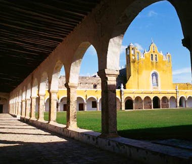
Izamal
Izamal is a beautiful colonial city founded in the mid-16th century on the remains of an ancient Mayan city. This place is known as "City of the Hills", recalling the covered pyramids that were there when the Spaniards arrived, as well as "The City of the Three Cultures" because it combines features of its pre-Hispanic past, of the colonial period and of the present time. Currently, all painted yellow and white by the will of authorities and neighbors, it maintains an image of elegance and charm from past times that distinguishes it and defines it with a stately air in the regional context.
In its neat patterned streets, horse-drawn buggies take the visitor on a charming tour of its squares and parks and its historic suburbs. At night, the city offers a unique experience, when contemplating a starry sky vault cut out by the profiles of its pyramids, temples and colonial mansions; shadows that seem to awaken from a dream of centuries. Izamal is located 72 km east of the city of Mérida.
https://www.yucatan.gob.mx/?p=izamal

Plaza Grande, Calle 60, Centro, Mérida, Yucatan, Mexico
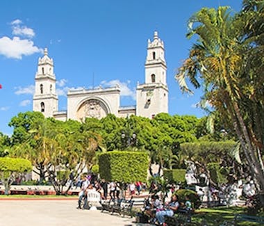
Plaza Grande
The scene of multiple events in the social, political, cultural and religious life of the Yucatecan community, from its construction in 1573 to the present day, the main square or known as "Plaza Grande", is one of the important symbols of Mérida.
This public square was the first to be built once the founding of the city was completed, on January 6, 1542. Three decades after Francisco de Montejo, “El Mozo”, founded Mérida de Yucatán, King Felipe II ordered that the Plaza Mayor of every Spanish city should be erected in the center of the town.
The historian Juan Francisco Peón Ancona, chronicler of Mérida, recalls that the Plaza Mayor or Principal (as it is officially called) was built on the Mayan remains of the ancient “Tho” or “Ichcaansihó”. “The Plaza Mayor, since its construction, has always been the geographic center of the city, and in colonial times the main people lived in the neighboring or front houses. In the solar of the north flank the House of the Governors or General Captains was raised; to the east, the Cathedral of San Ildefonso; towards the west, the Town Hall or Casa del Cabildo, and to the south, the Casa de Montejo ”, indicates Peón Ancona (Personal communication, February 3, 1996).
http://www.explore.mx/pasado-y-presente-de-la-plaza-grande/